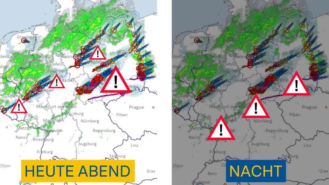
Please take a look at the radar and official weather warnings in the coming hours. After the supercells have moved across Saxony and southern Brandenburg, new and strong thunderstorms are forming again south of the continuous rain areas. This currently affects a zone from North Rhine-Westphalia through Thuringia to East Lower Saxony. New heavy rain is on the way, along with hail and strong gusts of wind. Three aspects need to be highlighted: A severe thunderstorm complex has recently formed near Erfurt, which is likely to bring heavy rain, strong gusts of wind, and hail of 4 to 5 centimeters. This could possibly be the next supercell, which could be quite long-lasting. Track: Weimar, Jena, and then towards Halle/Leipzig! The thunderstorm could arrive here right on time for the European Football Championship match!
Currently, multiple cells are passing over the same regions repeatedly, increasing the risk of flooding. This applies to the area from Erfurt to Halle/Leipzig, as well as regions in the southeast of Lower Saxony and large parts of North Rhine-Westphalia. New thunderstorms are following in a region from Rhineland-Palatinate to North Baden-Württemberg over to Franconia, Saxony, and Brandenburg, possibly even up to Berlin. This will likely continue into the early morning. Severe weather is possible again, locally even probable. Severe storms are already lined up over France and heading towards Germany. Please keep an eye on the radar and official weather warnings in the next hours.
Wednesday’s Forecast:
On Wednesday morning, the storms in Lusatia and the eastern mountainous region will gradually subside. Throughout the day, possibly already in the morning, isolated strong thunderstorms with heavy rain, hail, and gusty winds may occur in southern Germany. During midday and afternoon, there is also a localized risk of severe weather due to heavy rain and larger hail. In the border area between Saxony and Brandenburg, very intense thunderstorm cells are currently moving along. These seem to be particularly dangerous supercells. The thunderstorm cells are rotating strongly and are particularly susceptible to tornadoes when combined with strong updrafts and downdrafts!
Currently affected are the regions between Großenhain and Dahme/Mark with supercells in the southern area between Großenhain and Elsterwerda. They are now moving towards Senftenberg, Calau, Lübbenau, and then further to Bautzen, Hoyerswerda, Spremberg, and Cottbus. In these areas, please exercise caution against hurricane-force winds, larger hail, heavy rain, and possible tornadoes.
Additional Insights:
Super cells are the largest known storm structures with a diameter of 20 to 50 kilometers at their base. They are dangerous and can produce severe weather conditions. Lightning strikes are extremely intense in these storms, with around 3 strikes per second!
Leipzig Connewitz reported wind speeds of 85 km/h, a significant gust that can cause damage to trees and objects. It is highly likely that there was hail, possibly up to 4 cm in size. Rainfall ranged from 10 to 20 liters, possibly slightly more locally. The cell moved quite quickly, so the overall rainfall was not as high.
The hailstones are getting larger with intensifying storms. Radar analyses estimate hailstone sizes, with sizes ranging from 3 to 6 centimeters in the most severe cases. The risk of sudden gusts of wind is also growing, with possible wind speeds of just over 100 kilometers per hour. This mainly affects the storm cells from Franconia to northern Thuringia.
Stay tuned for more updates on the evolving storm situation.


